|
||

|

|
|

|
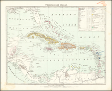
Striking, Rare Map of the Caribbean and Gulf of Mexico Referencing Two Colonial Wars
Fine, original-color map showing the Gulf of Mexico, Caribbean, Florida, Central America and the northernmost coast of South America. It was originally made to illustrate the theater of the Nine Years’ War (1688-1697), one of the many inter-imperial conflicts of this period. This is the 1740 reissue when, ironically, another war, the War of Austrian Succession, made the map relevant again as the area remained a a seat of war.
The map shows political divisions (marked with a dotted line), as well as cities (a building), villages (a dot), archbishoprics (a double cross), and bishoprics (a single cross). There are also indigenous groups and missions marked. As for geographic features, capes and rivers are demarcated, and many trees are drawn in to show the density of tree cover in some places. There is more detail in South and Central America than in North America, a reflection of the state of geographic knowledge at this time.
A key in the upper left explains the various symbols, and a scale in the upper right lays out distances in three different measures. Two winged cherubs hold a sheet up as the title cartouche in the upper right corner.
At sea, there are several obstructions noted, which underlines how tricky it is to navigate these waters. Small islands, rocks, and sand banks are all included. Three compass roses also dot the seas. Additionally, anchor points are marked, although this map would be used mare as a reference material than as a navigational aid.
In Florida, or Florida Hispanica as it is labeled here, the peninsula is called Tegesta Prov. The province of Tegesta is a Dutch convention pioneered by Hessel Gerritz, hydrographer to the Dutch East India Company and the Dutch West India Company, and Johannes de Laet. It refers to the Tegesta people, an indigenous group active near what is today Miami-Dade. The Tegesta were one of the first groups to meet Europeans, specifically the conquistadores Ponce de Leòn and Pedro Menéndez de Avilés.
Between the key and the scale at the top, another title explains that this map shows the seat of war in the Americas. This originally referred to the Nine Years’ War (1688-97), or the War of the Grand Alliance. In North America it is referred to as King Williams’ War. As with many seventeenth and eighteenth-century conflicts, this was a war for power in Europe that spilled into colonies around the world. Louis XIV of France invaded the Holy Roman Empire in September 1688 in order to make them accept his recent territorial gains. However, the German princes resisted, forming a large coalition that included Savoy, the Spanish, the Dutch and the English. In the Caribbean, fighting focused on harassing French convoys intent on resupplying their colonies.
This is a 1740 reissue by the Ottens. The map was again relevant as a theater of war because the European power were again at each others' throats over the power of the Hapsburg Monarchy. The war had actually started in 1739 in the Caribbean as the War of Jenkins Ear, when hostilities over illicit trade between the British and the Spanish led to Britain declaring war in 1739. Vice-Admiral Edward Vernon sacked Portobello at the end of that year. The war was later subsumed into the larger War of Austrian Succession, which had significant battles in the Caribbean.
Of particular note on this map are the shipping routes used by the Spanish Empire, the area’s most powerful imperial power at this time. Included is the Bahamas Channel route to Havana, the route from Veracruz to Havana, Havana to Cartagena, and Cartagena to Spain. The Spanish Empire operated a closed trading system, only allowing Spanish vessels to dock at and trade with ports in their colonies. The arrival of the galleon annually or semi-annually was a major event in the port cities, triggering fairs and festivities. Of course, much illicit trade also went on, often with Spain’s enemies, the French, Dutch and English.
This is an important map marking two volatile historical moments. It is also a fine depiction of the region and would make a significant addition to any collection of the Caribbean or the Gulf Coast.
The Ottens brothers, Reiner and Joshua, operated a successful printing partnership in the mid-eighteenth century (fl. 1726-1765). They began the venture in 1726, publishing maps and other prints as “R & I Ottens.” They specialized in the reprinting of others’ work, especially Guillaume De L’Isle. In 1750, Reiner died; his soon, also Reiner, took his place, but the firm began listing their works as “Joshua & Reiner Ottens.” The firm lasted until Joshua’s death in 1765. Joshua’s widow, Johanna de Lindt, sold their remaining stock of plates in 1784.
![(18th-Century Southern Borderlands) [Collection of manuscript letters to Secretary of War James McHenry from confidential U.S. agent John McKee, relating to southern borderlands, Native Americans and Panton, Leslie & Co.; a letter from John McKee written from Mobile, Alabama, to William Blount of Blount's Conspiracy fame; a letter from William Panton concerning John McKee; and letters from Felix D. St. Hilaire, concerning General Victor Collot]](https://storage.googleapis.com/raremaps/img/small/90005.jpg)