![[ India ] Magni Mogolis Imperium By Willem Janszoon Blaeu](https://storage.googleapis.com/raremaps/img/small/99730.jpg)


|
||

|

|
|

|
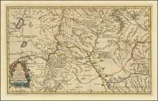
An attractive map of the region bounded by Pakistan, Afganistan and Bangladesh and extending inland up the Ganges and Indus Rivers to Tartary and the Himalayas, including Katmandu, Kabul and other legendary cities along the great trading route. Extends south to include a large portion of India, including Narsinga, Orixa Decan, etc. Elephants shown roaming the Ganges and Camels east of Kabul. Decorative cartouches and sailing ships. From a Dutch edition of Blaeu's Atlas Maior. A nice example in full orginal color. Minor tears in the margin, far from the printed image.
Willem Janszoon Blaeu (1571-1638) was a prominent Dutch geographer and publisher. Born the son of a herring merchant, Blaeu chose not fish but mathematics and astronomy for his focus. He studied with the famous Danish astronomer Tycho Brahe, with whom he honed his instrument and globe making skills. Blaeu set up shop in Amsterdam, where he sold instruments and globes, published maps, and edited the works of intellectuals like Descartes and Hugo Grotius. In 1635, he released his atlas, Theatrum Orbis Terrarum, sive, Atlas novus.
Willem died in 1638. He had two sons, Cornelis (1610-1648) and Joan (1596-1673). Joan trained as a lawyer, but joined his father’s business rather than practice. After his father’s death, the brothers took over their father’s shop and Joan took on his work as hydrographer to the Dutch East India Company. Later in life, Joan would modify and greatly expand his father’s Atlas novus, eventually releasing his masterpiece, the Atlas maior, between 1662 and 1672.
![[Iran, Afghanistan, Turkmenistan, Uzbekistan and Kazakhstan] Tabula Asiae VII](https://storage.googleapis.com/raremaps/img/small/84898.jpg)