|
||

|

|
|

|
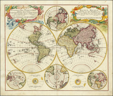
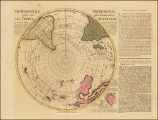
Scarce 3rd state of De Wit's striking double hemisphere shows the island of California and partial shorelines of western Australia and New Zealand. The map has been substantially revised from the original 1668 De Wit edition, engraved by Romyn De Hooghe, and now includes nice details in Southeast Asia, including a very curiously place Quiro Regio, which is a misplaced northern coast of Australia, displaced to appear directly above New Zealand. The map also includes a very bold and confident depiction of Terra Esonis, the mythical land bridge which virtually connects Japan and California. The depcition of the Southern Hemisphere is also signficantly revised, most notably additing Australia and Southern Africa. Includes an advanced depiction of the five Great Lakes, with Lakes Superior and Huron with open-ended western shores. The exquisite scenes surrounding the map are among the finest decorative motifs on early maps, rendered in life-like detail. They were etched (rather than engraved) by the important Dutch artist Romeyn de Hooghe. These lively scenes represent the four elements. Fire is shown by war and destruction; air by the heavens; earth by harvesting and husbandry; and water by ships, a spouting whale and mermaids. There are groups of figures tucked between the hemispheres with polar projection maps above and below. This scarce third state bears the imprint of Reiner and Josua Ottens. Repaired tears at lower centerfold, extending into the southern hemispheric image. Fine old colored example (refreshed) Shirley 444.
The Ottens brothers, Reiner and Joshua, operated a successful printing partnership in the mid-eighteenth century (fl. 1726-1765). They began the venture in 1726, publishing maps and other prints as “R & I Ottens.” They specialized in the reprinting of others’ work, especially Guillaume De L’Isle. In 1750, Reiner died; his soon, also Reiner, took his place, but the firm began listing their works as “Joshua & Reiner Ottens.” The firm lasted until Joshua’s death in 1765. Joshua’s widow, Johanna de Lindt, sold their remaining stock of plates in 1784.
De Wit (1629 ca.-1706) was a mapmaker and mapseller who was born in Gouda but who worked and died in Amsterdam. He moved to the city in 1648, where he opened a printing operation under the name of The Three Crabs; later, he changed the name of his shop to The White Chart. From the 1660s onward, he published atlases with a variety of maps; he is best known for these atlases and his Dutch town maps. After Frederik’s death in 1706, his wife Maria ran the shop for four years before selling it. Their son, Franciscus, was a stockfish merchant and had no interest in the map shop. At the auction to liquidate the de Wit stock, most of the plates went to Pieter Mortier, whose firm eventually became Covens & Mortier, one of the biggest cartography houses of the eighteenth century.
![[Title Page - Backwards World Map! / California as an Island]](https://storage.googleapis.com/raremaps/img/small/41754.jpg)