- Antique Maps
- United States
- Southeast
- Florida
The item illustrated and described below is sold, but we
have another example in stock. To view the example which
is currently being offered for sale, click the
"View Details" button below.
Map Maker
Title
Florida
Publication Place / Date
Philadelphia / 1850
Image Dimensions
12 x 14.5 inches
Color
Hand Colored
Condition
VG-
Stock# 1381
SOLD
Map Maker
Authenticity Guarantee
All of our maps are authentic antique maps, printed or drawn on or about the date shown in the description. In rare instances when we offer facsimiles, we will specifically describe the map as a later facsimile and include the date of publication. Certificates of Authenticity are included with each item.
Map Maker
Fast, Global Shipping
Last year we shipped over 4,500 antique maps to more than 50 countries. Maps are shipped Monday through Friday year-round. If an order is received before 2 PM PST, we will ship the order that day. If an order is received after that time, we will ship the next day. We ship maps either flat in custom packages or in specially ordered thick tubes. Shipping rates are provided as part of the checkout process.
Description
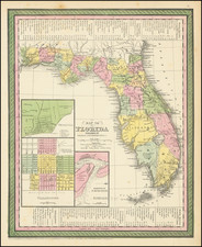
Attractive map of Florida, colored by county, w/insets of Pensacola, Tallahassee and Harbour of St. Augustine. Shows towns, railroads, roads, forts, lakes, rivers, swamps, keys, Indian information including Dade Massacre, etc. Detailed keys show various water routes. Moderate age toning.
Related Categories
Related Items