


|
||

|

|
|

|
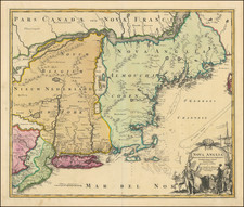
Striking full color example of Homann's map of the Northeast, extending North to include Maine and the St. Lawrence and South to include virtually all of New Jersey.
Glorious decorative cartouche, soundings and a host of other details on land and sea. Nice dark impression, with attractive full color.
Johann Baptist Homann (1663-1724) was a mapmaker who founded the famous Homann Heirs publishing company. He lived his entire life in Bavaria, particularly in Nuremberg. Initially, Johann trained to become a priest before converting to Protestantism and working as a notary.
In 1702, Johann founded a publishing house that specialized in engravings. The firm flourished, becoming the leading map publisher in Germany and an important entity in the European map market. In 1715, Johann was named Imperial Geographer to the Holy Roman Empire by Charles VI and made a member of the Prussian Academy of Sciences. Most importantly for his business, his reputation and contacts gained him imperial printing privileges which protected his publications and recommended him to customers. Johann is best known for this Grosser Atlas ueber die ganze Welt, or the Grand Atlas of the World, published in 1716.
After Johann died in 1724, the business passed to his son, Christoph (1703-1730). Upon Christoph’s early death, the company passed to subsequent heirs, with the name of the company changing to Homann Erben, or Homann Heirs. The firm continued in business until 1848.
![[ Cape Hatteras to New York City ] The Coast of the United States of North America; from New York to St. Augustine: Drawn and regulated according to the latest Surveys and Astronomical Observations By Edmund Blunt. Additions to 1839 & 1840](https://storage.googleapis.com/raremaps/img/small/84684.jpg)
![[ Temperance Allegorical View ] Black Valley Railroad. Tickets Sold at all Liquor Shops. Accidents by Collisions are Entirely Avoided, as no up Trains are Run Over the Road.](https://storage.googleapis.com/raremaps/img/small/101469.jpg)
![[Pennsylvania, New Jersey, New York ] Speciel Land Charte von Pensilvanien, Neu Jersey, Neu York und von denen drey Land-schafften an dem Delaware Fl. In America in Englischer Spr. gedruckt A. 1749 In Europa duffgelegt in Teutsch Spr. zu Francfurt am M. A. 1750.](https://storage.googleapis.com/raremaps/img/small/51958.jpg)