


|
||

|

|
|

|
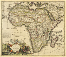
Decorative and highly detailed map of Africa, based upon an earlier map by De Wit. The Nile finds its source in two massive lakes in Central Africa and the Niger River's course is quite prominent, again flowing from lakes in the center of the continent. Highly detailed, with an attractive cartouche. Ottens maps are quite scarce.
The Ottens brothers, Reiner and Joshua, operated a successful printing partnership in the mid-eighteenth century (fl. 1726-1765). They began the venture in 1726, publishing maps and other prints as “R & I Ottens.” They specialized in the reprinting of others’ work, especially Guillaume De L’Isle. In 1750, Reiner died; his soon, also Reiner, took his place, but the firm began listing their works as “Joshua & Reiner Ottens.” The firm lasted until Joshua’s death in 1765. Joshua’s widow, Johanna de Lindt, sold their remaining stock of plates in 1784.
![[Africa] (2 maps - Ancient & Modern)](https://storage.googleapis.com/raremaps/img/small/70579.jpg)
![[ Canary Islands and Madeira Islands ] Isola di Canarie. . [with] Isola Madeira](https://storage.googleapis.com/raremaps/img/small/98646.jpg)