This item has been sold, but you can enter your email address to be notified if another example becomes available.


|
||

|

|
|

|
Stock# 13058
Description
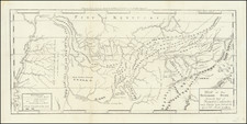
Rare large format map of Tennessee, published at the beginning of the Civil War.
The map is hand colored by county, and shows towns, roads, railroads, rivers, mountains, lakes, mills, caves, post offices, canals, etc. Includes advertising for Lloyd's other maps and a solicitation for agents to sell the maps. One of the most detailed maps of Tennessee of the period and one of the largest.
Condition Description
Flattened and backed on japan paper, with very minor loss at intersections, but generally a very nice example of this hard to find map.