


|
||

|

|
|

|
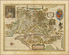
A nice example of Hondius' map of Virginia, Maryland and the Chesapeake region, from the Atlas Novus. This map is the first state of Hondius' map. The map depicts the discoveries in the region detailed by John Smith in his map of 1612. This map was the first widely disseminated version of the Smith map and therefore highly influential on other maps of the period and became the standard map of the region until Augustine Hermann's map of 1673. The map is one of the most detailed maps of the Chesapeake region to date and is an essential map for collectors of this region. Nice dark impression. Minor offsetting and minor centerfold split, just touching printed image, but generally a nice example in old color with nice wide margins.. Burden 228.
Henricus Hondius (1597-1651) was a Dutch engraver and mapmaker, a member of a prominent cartographic family. His father, Jodocus Hondius, was also an engraver and geographer. While working with his father, Henricus was instrumental in the expansion and republishing of Mercator’s atlas, first published in 1595 and republished by Hondius in 1606.
Upon his father’s death in 1612, Henricus and his brother, Jodocus the Younger, took over the business. He set up his own shop in 1621, where he continued to release new editions of the Mercator atlas. Later, he partnered with his brother-in-law, Jan Janssonius, in continuing to expand and publish Mercator’s atlas, which would become known as the Mercator-Hondius-Janssonius atlas. Born and based in Amsterdam, he died there in 1651.
![[Pennsylvania, New Jersey, New York ] Speciel Land Charte von Pensilvanien, Neu Jersey, Neu York und von denen drey Land-schafften an dem Delaware Fl. In America in Englischer Spr. gedruckt A. 1749 In Europa duffgelegt in Teutsch Spr. zu Francfurt am M. A. 1750.](https://storage.googleapis.com/raremaps/img/small/51958.jpg)

![[ Middle British Colonies Map ] Pensilvania Maryland and Virginia](https://storage.googleapis.com/raremaps/img/small/98228.jpg)
![(Civil War) Stanford's Map of the Seat of War in America. Sheet I. [Mid-Atlantic States]](https://storage.googleapis.com/raremaps/img/small/96007.jpg)
