![(Apian World Map) La Cosmographia de Pedro Apiano, corregida y añadida por Gemma Frisio ... El Sitio y Descripcion de las Indias y Mundo Nuevo, sacada de la Historia de Francisco Lopez de Gomara, y de la Cosmographia de Ieronymo Giraua Tarragonez [with map:] Mappa Mundi By Peter Apian](https://storage.googleapis.com/raremaps/img/small/100234.jpg)


|
||

|

|
|

|
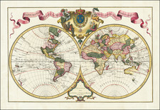
The second state of this World map which first appeared in the 1544 in Apian's Cosmographia, which was based on a larger map of the world prepared by Gemma Frisius in 1540 in Louvain, of which there is no known example according to Shirley (Entry 82). The map represents one of the earliest obtainable world maps not based upon the works of Ptolemy. The map includes a Northwest passage, above which is a fascinating Asian projection. North America, called Baccalearum for its Cod fisheries. The narrow Straits of Magellan represent the only passage between South America and an understated Southern Continent. The map is embellished by sea monsters, mermaids, windheads, etc. An excellent example of a cordiform world map. Shirley 96. Reinforced at the centerfold, else a nice example.

![[Map of the World on a Globular Projection Exhibiting Particularly the Nautical Researches of Capn. James Cook, F.R.S. with all the Recent Discoveries to the Present Time carefully Drawn by A. Arrowsmith . . . ]](https://storage.googleapis.com/raremaps/img/small/94140.jpg)