The item illustrated and described below is sold, but we
have another example in stock. To view the example which
is currently being offered for sale, click the
"View Details" button below.
![[ British Colonies in North America ] Carte Nouvelle de L'Amerique Angloise contenant tout ce que les Anglois possedent sur le Continent de L'Amerique Septentrionale . . . By Mathais Albrecht Lotter](https://storage.googleapis.com/raremaps/img/small/100143.jpg)


|
||

|

|
|

|
Stock# 12861
Description
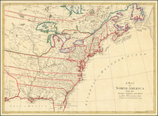
Finely colored example of Lotter's map of the British Colonies, which identifies each of the 13 Colonies by name in the title and in the map, at the outbreak of the American Revolution. Nice treatment of the colonies, although Maryland is given a very curious shape for the time period. Includes nice detail in the Great Lakes region and a few places named in the Ohio Valley, including Logs Town, Twictwees, Ft. Du Quesne, Allegheny, Vinango, Buffaloons, Sandoski and Mingos. Ft. Necessite is also shown. The map is very Franco-centric, limiting the claims of the Britishto the regions east of the Appalachian Mountains. Ornate decorative cartouche.

![Trails: [1595-1945]: Land, Sea, and Air of The American Adventure Series](https://storage.googleapis.com/raremaps/img/small/70672.jpg)