The item illustrated and described below is sold, but we
have another example in stock. To view the example which
is currently being offered for sale, click the
"View Details" button below.
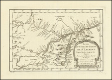
1757 Jacques Nicolas Bellin
$ 195.00


|
||

|

|
|

|
Stock# 12840
Description
Detailed map of the St Laurence, from Quebec to Lake Ontario, centered on Montreal. Issued at the outset of the French & Indian War. Shows Lake Champlain and Lake George areas. Also shows all of Lake Champlain and Lake George. Fort Edward, Fort George and Fort Carillon are depicted as well.
![[MacKenzie River, Yukon Territory and Northwest Territory] Amer. Sep. No. 15. Grand Lac De L'Esclave](https://storage.googleapis.com/raremaps/img/small/19469.jpg)
![[Unique Extra-Illustrated Example!] Carte Nouvelle Contenant La Partie d'Amerique La Plus Septentrionale, . . . Le Canada ou Nouvelle France, La Nouvelle Ecosse, La Nouvelle Angleterre, Les Nouveau Pais Bas, La Pensylvanie . . . Et Jle. de Terre Neuve . . .](https://storage.googleapis.com/raremaps/img/small/47720.jpg)