This item has been sold, but you can enter your email address to be notified if another example becomes available.


|
||

|

|
|

|
Stock# 12792
Description
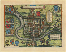
Attractive full color example of Christopher Saxton's map of the East Riding, from the 1637 edition of Camden's Britannia. The first map of the East Riding, reduced from a section of the Saxton map of Yorkshire by William Hole. The map includes a decorative cartouche and two compass roses. William Camden first issued his Britannia in 1586, but did not include maps until the 1607 edition. The maps in the 1637 edition are essentially unchanged from the 1607 edition.