|
||

|

|
|

|
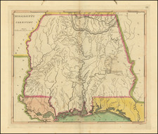
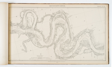
Important early map of Kentucky, showing primarily the region around the Ohio and Tennessee Rivers, from northern Georgia to Western Territory. Centered on the Cumberland River. Shows Southwestern Territory, Tennessee Government, area reserved for the North Carolina Troops, Donation Lands from the Commonwealth of Virignia, etc. A number of counties are located, as are towns, roads, rivers, court houses, etc. The map first appeared in Winterbotham's View of the American United States. Includes all of Kentucky, most of Tennessee, called South Western Territory and Tennessee Government. Upper left is North Western Territory with tracts called New Jersey Company, Wabash Company and Genl. Clarks Grant 150,000 Acres. Extends west to New Madrid, south to Creeks Crossing Place and a fort near Muscle Shoals, east to Harmans Station in Kentucky. Settlements include Knoxville, Nashville, Clarksville, (in Tenn.) Lexington, Louisville, Bairds Town (sic). Shows forts, traces, trails, etc. One of the most interesting regional maps of the period. The map was published in Reid's American Atlas, with the map bearing the name of A Anderson as engraver and published by Smith, Reid & Wayland.