![Pascaart vertoonende de zeecusten van Chili, Peru, Hispania Nova, Nova Granada, en California…. [Early New Zealand Inset] By Hendrick Doncker](https://storage.googleapis.com/raremaps/img/small/65168.jpg)


|
||

|

|
|

|
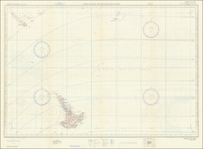
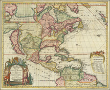
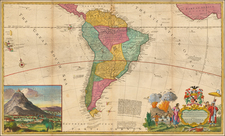
Scarce early search chart, showing the West Coast of the Pacific Ocean, which extends from the Island of California to Chili, with noteworthy insets of New Zealand, the Ladrones and Japan & Ieso.
The projection of California based upon Sanson's maps of 1656, show even greater sea between California and the mainland. The Canal de Santa Barbara, Monte Rey, P. Concepsion, S. Diego, Mendocino, S. Quentin, C. Blanco, and many other early placenames appear. Excellent detail throughout the Pacific Coast. This is one of the earliest regional maps to focus on the Pacific Coast. In addition to the remarkable treatment of California and the Pacific Coast, the inset of New Zealand is a wonderful early detailed treatment of Abel Tasman's discoveries in New Zealand, including 5 placenames.
Hendrik Doncker was a famous bookseller in Amsterdam, who started at the age of 22 years, and ran his shop successfully for fifty years. He published his first sea atlas around 1659. Due to the fact, that Hendrik Doncker corrected and improved his charts more frequently then other well known map makers, as van Loon, Goos or Theunis, his business was quite successful, and there was a high demand for his works. This reflected also in the various improved and corrected editions of sea atlases he published. This map was published in a composite sea atlas by Pieter Goos, who was 'one of the best known maritime booksellers of Amsterdam' (Koeman). He published a number of different sea-atlases or pilot books, and his work was very much derivative. With his 'Zee-Atlas' he relied heavily on Hendrick Doncker's 'Ze e-Atlas' of 1659.
Hendrik Doncker was a prominent bookseller in Amsterdam best known for his sea charts and nautical atlases. He issued his own original charts, which he updated frequently, and also worked with colleagues like Pieter Goos, for example to produce the pilot guide, De Zeespeigel. He died in 1699, after fifty years in business. His plates then passed to Johannes van Keulen.