


|
||

|

|
|

|
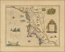
Striking wide margined example of Blaeu's map of New England and the Northeast. Blaeu's map of New England is noted for the fact that its primary source is the first manuscript figurative map of Adriaen Block, 1614. Indeed it is the first full representation of it in print. Block was Dutch a fur trader whose exploration of the area between Cape Cod and Manhattan helped to create the first accurate picture of the longitudinal scale of the coastline. Although Blaeu's map depends on the Block manuscript map for much of its geography, it also improves upon Block by reconnecting Cape Cod to the mainland, and separating the source of the Hudson and Delaware Rivers, which had been causing some confusion. Nieu Amsterdam is correctly marked as a fort on the tip of the island, and the coastline south of Sandy Hook also shows signs of improvement. Blaeu's map is adorned with numerous vignettes of animals, including the first appearance of beavers and polecats on a printed map. Burden calls this map one of the most attractive maps of the Americas at the time and notes that the Mohawk Indian village on the top right is derived from the de Bry/White engravings. An attractive example, with full wide margins, with Dutch text on the verso. An essential map for New England and Northeastern collections. Burden #241.
Willem Janszoon Blaeu (1571-1638) was a prominent Dutch geographer and publisher. Born the son of a herring merchant, Blaeu chose not fish but mathematics and astronomy for his focus. He studied with the famous Danish astronomer Tycho Brahe, with whom he honed his instrument and globe making skills. Blaeu set up shop in Amsterdam, where he sold instruments and globes, published maps, and edited the works of intellectuals like Descartes and Hugo Grotius. In 1635, he released his atlas, Theatrum Orbis Terrarum, sive, Atlas novus.
Willem died in 1638. He had two sons, Cornelis (1610-1648) and Joan (1596-1673). Joan trained as a lawyer, but joined his father’s business rather than practice. After his father’s death, the brothers took over their father’s shop and Joan took on his work as hydrographer to the Dutch East India Company. Later in life, Joan would modify and greatly expand his father’s Atlas novus, eventually releasing his masterpiece, the Atlas maior, between 1662 and 1672.
![[ Cape Cod to Acadia ] Pas-Kaart Vande Zee Kusten inde boght van Niew Engeland Tusschen de Staaten Hoek en C.de Sable . . .](https://storage.googleapis.com/raremaps/img/small/94453.jpg)
![[ Bunker Hill ] A Plan of the Action at Bunkers Hill on the 17th of June 1775 between His Majesty's Troops, Under the Command of Major General Howe, and the American Forces . . .](https://storage.googleapis.com/raremaps/img/small/70223.jpg)


![[British Colonies in America] Carte Qui Contient Une Description Des Iles & Terres Que Les Anglois . . .[maps of Chesapeake, Carolinas, New England, Bermuda, Gulf Coast, Jamaica, Barbadoes & Canada]](https://storage.googleapis.com/raremaps/img/small/61480.jpg)