This item has been sold, but you can enter your email address to be notified if another example becomes available.


|
||

|

|
|

|
Stock# 12699
Description
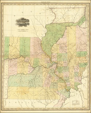
Rare 1859 edition of Charles Desilver's map of Missouri, hand colored by counties and showing towns, roads, railroads, proposed rail lines, rail lines under construction, canals, steamship lines, etc. Includes township surveys and a host of other interesting details. Just west of Missouri is Indian Territory, including over a dozen early Indian Reservations. staining in the margins, but a nice example.