


|
||

|

|
|

|
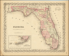
Marvelous pre-Civil War map of Florida, with a large inset plan of the Keys. The south is dominated by Dade, Monroe, Brevard, Mantee, and Hillsboro Counties. The state surveys have crossed the state, but still have not been completed in Monroe and Dade counties, which are still largely shown as swamp lands. A number of forts appear throughout the map. Also names early roads, rivers, lakes, islands, Indian areas (Bowlegs Land) and a host of other details. Fine attractive color and decorative border.
G. W. & C. B. Colton was a prominent family firm of mapmakers who were leaders in the American map trade in the nineteenth century. The business was founded by Joseph Hutchins Colton (1800-1893) who bought copyrights to existing maps and oversaw their production. By the 1850s, their output had expanded to include original maps, guidebooks, atlases, and railroad maps. Joseph was succeeded by his sons, George Woolworth (1827-1901) and Charles B. Colton (1831-1916). The firm was renamed G. W. & C. B. Colton as a result. George is thought responsible for their best-known work, the General Atlas, originally published under that title in 1857. In 1898, the brothers merged their business and the firm became Colton, Ohman, & Co., which operated until 1901, when August R. Ohman took on the business alone and dropped the Colton name.


![[ Carolinas & Georgia ] Carte De La Caroline Et Georgie . . .](https://storage.googleapis.com/raremaps/img/small/99744.jpg)
