
The item illustrated and described below is sold, but we
have another example in stock. To view the example which
is currently being offered for sale, click the
"View Details" button below.


|
||

|

|
|

|
Stock# 12632
Description
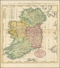
Interesting map of Ireland, hand colored by counties. Shows towns, roads, rivers, lakes, mountains, Islands, bays, points, etc. 32 counties named. Minor fold split and a bit of offsetting, but a good example. From the 1814 edition of Carey's General Atlas, one of the earliest large format atlases published in America.

![[Jamestown, Saint Helena] Plan de la Forteresse et Bourg, De L'Isle De St. Helene](https://storage.googleapis.com/raremaps/img/small/77017.jpg)
![(Northern Scandinavia) Carte des Couronnes du Nord Dediée Au très Puissant et très Invincible Prince Charles XII, Roy de Suède, des Gots et des Vandales, Grand Duc de Finlande, &c. &c. &c. [Map of the Northern Crowns Dedicated to the Very Powerful and Invincible Prince Charles XII, King of Sweden, of the Goths and Vandals, Grand Duke of Finland, etc. etc. etc.]](https://storage.googleapis.com/raremaps/img/small/92675.jpg)