


|
||

|

|
|

|
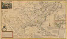
Striking full color example of Moll's map of North America, including California as an island. The map is one of four large maps of North America by Moll and distinguished him as the leading English mapmaker of the early 18th Century. This map, featuring the inset of the Sasquesahanok map is probably the most detailed and interesting in its treatment of the whole of the US, Canada & Mexico. The map's detailed treatment of Texas, includes explorers routes and dates. The treatment of the Mississippi and Missouri Valleys are extraordinary, if inaccurate. The projection of the Great Lakes, Gulf Coast, Florida and the Southwest are also outstanding. Large insets of Annapolis & the mouths of the Mississippi and Mobile. Too much detail to describe. Offered here in the second state, with John King added as one of the mapsellers. The map has been repaired and restored along the centerfold, with some paper restorations at the fold and along the margins. Because of its size and the manner in which it was bound into the atlas with three vertical folds, the folds of this map are rarely found without some loss and discoloration. A striking full color example of this increasingly rare map. In all, a nice example in gorgeous full color.
Herman Moll (c. 1654-1732) was one of the most important London mapmakers in the first half of the eighteenth century. Moll was probably born in Bremen, Germany, around 1654. He moved to London to escape the Scanian Wars. His earliest work was as an engraver for Moses Pitt on the production of the English Atlas, a failed work which landed Pitt in debtor's prison. Moll also engraved for Sir Jonas Moore, Grenville Collins, John Adair, and the Seller & Price firm. He published his first original maps in the early 1680s and had set up his own shop by the 1690s.
Moll's work quickly helped him become a member of a group which congregated at Jonathan's Coffee House at Number 20 Exchange Alley, Cornhill, where speculators met to trade stock. Moll's circle included the scientist Robert Hooke, the archaeologist William Stuckley, the authors Jonathan Swift and Daniel Defoe, and the intellectually-gifted pirates William Dampier, Woodes Rogers and William Hacke. From these contacts, Moll gained a great deal of privileged information that was included in his maps.
Over the course of his career, he published dozens of geographies, atlases, and histories, not to mention numerous sheet maps. His most famous works are Atlas Geographus, a monthly magazine that ran from 1708 to 1717, and The World Described (1715-54). He also frequently made maps for books, including those of Dampier’s publications and Swift’s Gulliver’s Travels. Moll died in 1732. It is likely that his plates passed to another contemporary, Thomas Bowles, after this death.
![[An English Propaganda Map In French] Carte Des Possessions Angloises & Francoises Du Continent De L'Amerique Septentrionale 1755.](https://storage.googleapis.com/raremaps/img/small/86975.jpg)
![Gen. Washington [On The Battlefield At Trenton] Engraved by W. Warner from the original picture by Col John Trumbull](https://storage.googleapis.com/raremaps/img/small/103233.jpg)
![Charte von Nord-America Prag 1818 [Rare Alaska Inset Map]](https://storage.googleapis.com/raremaps/img/small/72184.jpg)