This item has been sold, but you can enter your email address to be notified if another example becomes available.


|
||

|

|
|

|
Stock# 1254
Description
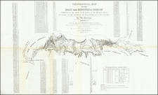
A nice example of HH Lloyd's scarce double page map of this portion of the Transmississippi West, centered on the Rocky Mountains. Tremendous detail throughout, too much early information to describe in detail. Includes counties, towns, railroads, mountains, rivers, explorer routes, US Mail Route, Indian lands and a host of other details. HH Lloyd never did issue his Atlas of the United States, but portion appeared in Warner & Beers Atlases during the 1870s. This map was only included in the earliest editions of the work. A few marginal tears, not touching the image, but in all, a very good example of this scarce map.
![[ Mexican Railroads ] Carta De Comunicaciones De Los Estados Unidos Mexicanos Formada de orden de la Secretaria de Estado y del Despacho de Comunicaciones y Obras Publicas, por el Coronel Bodo von Glumer . . . Primera Hoja. 1895 - 1896. (and) Segunda Hoja 1895 - 1896](https://storage.googleapis.com/raremaps/img/small/103235.jpg)

![Air Log Western Air Express [Los Angeles-San Diego, Las Vegas-Los Angeles, Milford-Vegas, Salt Lake City-Milford]](https://storage.googleapis.com/raremaps/img/small/85953.jpg)