|
||

|

|
|

|
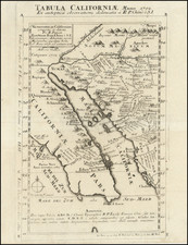
Extremely rare and important general coastal chart from that atlas produced to accompany the report of the final Spanish voyage of exploration on the Northwest Coast of America led by Galiano and Cayetano Valdes.
The map extends from just north of C. Blanco de Martin de Aguilar to Acapulco, centered on San Diego and the Channel Islands, with nice detail for San Francisco Bay.
Although the Espinosa y Tello maps were published four years after the Vancouver maps, Wagner considers them in many respects to be superior, and Humboldt used them in his Essai Politique sur le Royaume de la Nouvelle Espagne. Wagner further states: the general impression today...is that the English discoveries of Vancouver were published four years before those of the Spaniards. This...is a misapprehension... The principal reason, however, why the nomenclature and geography of Vancouver came to occupy the field was that his maps were extensively copied by the famous English cartographer, Aaron Arrowsmith, and later by the English Admiralty.
Following almost a century of warfare with England, generally due to disastrous alliances with France, Spain was forced to withdraw from the last great area of the globe to be explored, the Pacific Northwest Coast of America. Spanish claims, dating from the sixteenth century were nullified by the threat of war and the Nootka Convention of 1790, permitting the ultimate establishment of British hegemony in the region. In a final search for a passage between the Pacific and Atlantic oceans, in 1791 the Descubierta commanded by Alejandro Malaspina and the Atrevida under José Bustamante y Guerra explored the area of the Strait of Juan de Fuca and Vancouver Island, as well as some of the numerous inlets of the British Columbia and southeast Alaskan coast without encountering a passage.
Malaspina was not convinced that his work had been sufficiently exhaustive, and in 1792, an expedition comprising the Sutil under Dionisio Alcalá-Galiano and the Mexicana under Cayetano Valdés was dispatched from San Blas to finally settle the question. Alcalá-Galiano and Valdés circumnavigated Vancouver Island and explored in detail the inlets northward to the Queen Charlotte Islands, thus satisfying both Spain and England that an entrance to a passage south of the Cook Inlet did not exist.
The results of this final Spanish voyage of discovery in the North Pacific were prepared for publication by Martín Fernández de Navarrete (1765-1844) of the Depósito Hidrográfico in Madrid.
The work is extremely rare, with only 500 copies published in 1802. A fundamental map for California collectors and one of the rarest.
![[ Lake County Rancho ] Map of the Guenoc County Rancho Finally Confirmed To A.A. Ritchie & P.S. Forbes, Surveyed under the Direction of the U.S. Surveyor General By Wm. Denton Deputy Surveyor. June 1857.](https://storage.googleapis.com/raremaps/img/small/102630.jpg)
![Southeastern Portion of California [San Diego, San Bernardino and Inyo Counties]](https://storage.googleapis.com/raremaps/img/small/83750.jpg)