
This item has been sold, but you can enter your email address to be notified if another example becomes available.


|
||

|

|
|

|
Stock# 12107
Description
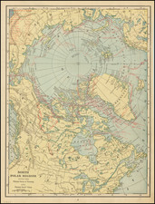
Scarce map of the routes of the British explorers to the Northwest and Northeast of Lake Winnepeg, during Franklin's explorations of the Polar regions of Canada. The map accompanied the first edition of Franklin's Narrative of his second expedition to the Arctic. Highly detailed map, including dozens of place names and field notes. An important milestone in the exploration of the region and pursuit of the Northwest Passage. Nice example, with full orginal margins.
![[East Coast of Prince Edward Island - Rollo Bay to Wood Islands]](https://storage.googleapis.com/raremaps/img/small/62849.jpg)
![[An English Propaganda Map In French] Carte Des Possessions Angloises & Francoises Du Continent De L'Amerique Septentrionale 1755.](https://storage.googleapis.com/raremaps/img/small/86975.jpg)
![[First State of the Popple Key Sheet] A Map of the British Empire in America with the French and Spanish Settlements adjacent thereto by Hen. Popple.](https://storage.googleapis.com/raremaps/img/small/92714.jpg)
![Hemisphere Septentrional du Globe Terrestre Veu en concave l'oeil estant au Pole AntArctique . . . 1696 [and] Hemisphere Superieur du Globe Terreste pour l'Horizon de Paris Veu en convexe l'oeil etant pose au zenith et a distance infinie du plan de projection . . . 1697](https://storage.googleapis.com/raremaps/img/small/85541.jpg)