
This item has been sold, but you can enter your email address to be notified if another example becomes available.


|
||

|

|
|

|
Stock# 12106
Description
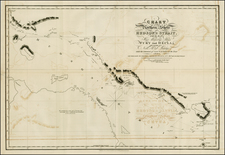
Scarce map of the NW Coast of America, Canada and Greenland, extending to Baffin Bay and the North Georgian Islands, illustrating the British Discoveries in the Arctic. The map accompanied the first edition of Franklin's Narrative of his second expedition to the Arctic, with his route from Lake Superior and Fort William to the Arctic Sea noted in Red. Includes nice detail in the Northwestern US and Canada, including a good snapshot of the Upper Missouri, Columbia and Fraser (unnamed) River regions, along with details along Franklin's route. An important milestone in the exploration of the region and pursuit of the Northwest Passage. Nice example, with full orginal margins, narrowed only in the upper left, as issued.
![[ Discovery of the Northwest Passage ] Chart Showing the Recent Search for a North-West Passage. Also the Coast Explored in Search of Sir John Franklin between the Years 1848 and 1854](https://storage.googleapis.com/raremaps/img/small/101874.jpg)

![[Title Page - Backwards World Map! / California as an Island]](https://storage.googleapis.com/raremaps/img/small/41754.jpg)
![[Route of the 1938 Westward Northwest Passage Cover] Map of the Northwest Territories 1929](https://storage.googleapis.com/raremaps/img/small/60046.jpg)