This item has been sold, but you can enter your email address to be notified if another example becomes available.


|
||

|

|
|

|
Stock# 12021
Description
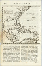
Interesting plan of the action at Hampton Roads and around Cape Henry and below Cape Charles. Shows the mouth of the Chesapeake Bay and the positions of the English and French ships and their lines of movement to the commencement of the engagement. The English fleet is shown blocking the bay. Most of the French fleet is off Lynn Haven Bay on the north side of Norfolk. From Stedman's, History of the . . . American War, one of the great compendiums of American Revolutionary War Battle Plans. Nebenzahl, Bibliography, 184. Birmingham Library stamp upper left.
![Carte Particuliere de Virginie, Maryland, Pennsilvanie, La Nouvelle Jarsey. Orient et Occidentale [Heighten in Gold!]](https://storage.googleapis.com/raremaps/img/small/61392mp2.jpg)