|
||

|

|
|

|
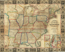
Walker's case map of the United States is one of the great rarities among early 19th Century English Case Maps of the United States. While based primarily upon David Vance's wall map of the United States of 1825, published in Philadelphia, Walker takes Vance's information and presents a magnificent map, of identical scale to the Vance, but which vastly surpasses the Vance in both detail and accuracy. The scale of Walker's map and its shear size dwarf contemporary maps by John Melish and others. Because of its scale and significant detail, it is arguable the most significant map of the United States published in England after Arrrowsmith's map. Includes a double-wide Arkansas Territory, extraordinary detail west of the Mississippi (including very early counties in the South and Midwest), the trader's route from Missouri to New Mexico, the Great Spanish Road, Road to the Pawnies, and early Western Forts and settlements. The treatment of Michigan Territory, Illinois, Northwest Territory and Missouri Territory, including the Missouri and Yellowstone Rivers, is unsurpassed. Good treatment of the NW Company Trading Housing. Only a few copies have been on the market since the Streeter copy in the 1960s. Illustrated by Rumsey, using a copy borrowed from another private collection. A near fine copy, with minor offsetting, as usual, in attractive outline color. Four sheets, each dissected and laid on linen. One of the truly great Americana maps of the post-Lewis & Clark period. Very rare. Streeter, Texas #1098. This example was apparently colored and dissected by James Wyld in his shop, as the style of the dissecting runs vertically, whereas all other examples are horizontal.
J. & C. Walker was the imprint used by the Walker family of engravers and printers. They produced numerous high-quality geographical maps and nautical charts for a variety of institutions in the nineteenth century. John Walker (1787-1873) held the position of Hydrographer to the East India Company, a position also held by his father and namesake. John worked in partnership with his brothers, Charles and Alexander. The brothers published over 200 maps for the Society for the Diffusion of Useful Knowledge. They produced maps for James Horsburgh and the Admiralty, as well as the influential Indian Atlas.
![[ US-Mexico Border Survey: General Order From the President of the United States Directing William H. Emory to lead the US-Mexico Boundary Survey ]](https://storage.googleapis.com/raremaps/img/small/101837.jpg)
![[ First Gold Rush Edition! ] Colton's Map of the United States of America, The British Provinces, Mexico, The West Indies and Central America . . . 1849](https://storage.googleapis.com/raremaps/img/small/101951.jpg)