
This item has been sold, but you can enter your email address to be notified if another example becomes available.


|
||

|

|
|

|
Stock# 11642
Description
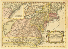
Detailed map of Maryland, Delaware, the Chesapeake and parts of New Jersey and Pennsylvania, engraved by Thomas Kitchin. The map shows towns, counties, roads, rivers, bays, and a host of other details. The map is bound with the text of the August 1757 edition of the London Magazine, which includes several interesting Colonial American articles, including an Account of the Six Nations of Indians, Dreadful Fire in Carolina And Terrible Hurricane and a map of the Toulon. The map of the Chesapeake is drawn from John Mitchell's seminal map of the British Colonies in North America and is on nearly the same scale. Jolly, Lond-122.


![[British Colonies in America] Carte Qui Contient Une Description Des Iles & Terres Que Les Anglois . . .[maps of Chesapeake, Carolinas, New England, Bermuda, Gulf Coast, Jamaica, Barbadoes & Canada]](https://storage.googleapis.com/raremaps/img/small/61480.jpg)