|
||

|

|
|

|
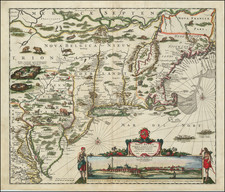
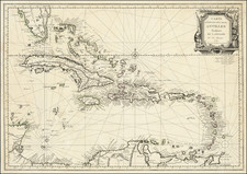
A nice example of Philip Lea's extremely rare map, which was first advertised in the Term Catalogues for Trinity Term 1685, published in June 1685. It is not referred to in Lea's1685 catalogue, but appears in the catalogue of 1687. The map is divided into three parts, the lower part being a detailed map of the island of Jamaica, naming all the plantation owners. It bears an inset lower left entitled A New Draught of Port Royal by Anthony Williams. The upper part of the map shows the Gulf of Mexico and the southeastern portion of North America. A large B. Sp of Santo represents the mouth of the Mississippi River, Florida includes a similarly named river on the west coast, and S Augustine on the eastern shore. The map extends to the Carolinas, with the ports of Charles Towne and Port Royall noted. A large inset map in the upper right is entitled The English Empire and extends the coverage of the map northwards through New England, centered on the Chespeake. This map provides an accurate depiction of the British Colonies along the Eastern Coast of North America as it stood in the mid 1680s. The new colony of Pennsylvania is shown, as is the capital city, misspelled Philidolphia. The four vessels plying the waters offshore indicate the level of trading activity. There was one unusual publication from this plate. In 1694 Thornton, Morden and Lea collaborated on the extremely rare Hydrographia Gallia, a small book of pocket maps of the coasts of France. Lea followed this on his own with the Hydrographia Universalis, c.1696. This was a little work of the harbors and coasts of the world although with a strong emphasis on England and France. Lea masked this plate to print the little inset of the English Empire and include it in the work. Only four examples have been located: British Library, National Maritime Museum and two at the Library of Congress. Philip Lea published a second very similar map of Jamaica most probably in the late 1690s, where the upper section of the map is replaced with images of the West Indies. Old centerfold split has been repaired on the verso, with minor remnants of soiling along the centerfold. Centerfold reinforced on verso. A few marginal tears, just reaching the printed image, but in all a very attractive example of this extremely rare and imporant map. Not in Cumming or McCorckle. There are only 4 known copies of the complete Philip Lea Atlas. Only one appearance of the map in a dealer catalogue in the past 25 years (Arkway, Catalogue 58--2003).
Philip Lea (fl. 1683-1700) was a central figure in the London map community at the end of the eighteenth century. He apprenticed under Robert Morden, with whom he later collaborated. Lea was made free of the Weavers Company in 1689. He was a publisher and a globe and instrument seller with ties to members of government. For example, Samuel Pepys lists him as his map advisor and colorist. He was not known primarily for his own original works, but for his reworking and reissuing of the work of others, particularly the county maps and world map of Christopher Saxton. He also acquired plates from John Seller, John Ogilby, and William Morgan, among others. Later in his career, he collaborated frequently with Herman Moll. After his death in 1700, Philip’s wife, Anne, carried on the business for several decades.