|
||

|

|
|

|
Stock# 11620
Description
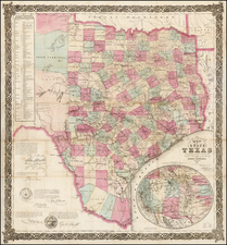
Detailed map of the Republic of Texas, issued in Tanner's Universal Atlas.
Approximately 40 counties are shown and separately hand colored, although the western 2/3rds of the Republic is dominated by Bexar, Milam, Robertson and San Patricio Counties. Fort Alamo is shown, along with a few dozen other place names. About 15 early roads are shown. Large inset shows Texas North of the Red River. A terrific map of the Republic, which was first issued in 1845, shortly before Tanner sold the rights to the Atlas to SA Mitchell. The Tanner edition of this map is quite scarce, and is often confused with Mitchell's 1846 issue (which is also dated 1845 on the map), but which can be distinguished by the difference in decorative borders.


![[First Obtainable Map to Name California] Tartariae Sive Magni Chami Regni typus](https://storage.googleapis.com/raremaps/img/small/82510.jpg)