


|
||

|

|
|

|
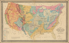
Interesting map of the United States, extending west to Texas, Spanish Peaks, the Black Hills, and the Mandan District, with a wonderful treatment of Texas as a Republic. The map is drawn in part from Emory's map of Texas and the maps of the plains by Hood and Stein. The map is colored to show the various Indina Districts west of Missouri and Arkansas Territory, including massive Mandan, Sioux, Dacotah and Chactaw Districts. Early misshapen Iowar is shown. A large note regarding the buffalo roaming the plains is present. Bent's Fort and Gant's Fort are shown, along with Long's Peak, Spanish Peak, Ft. Laramie and the Santa Fe Road from Independence. Nice detail in Texas. Large insets of areas around Boston, New York City and Philadephia. The map is laid on thin linen and was previously folded into a guide book. A bit of faint waterstaining in the upper corners, just entering the map image and a narrow lower left margin, but in all a very attractive example.


![[ Texas - Dallas to El Paso ] Flight Chart- Dallas Fort Worth to El Paso, U.S.A.](https://storage.googleapis.com/raremaps/img/small/98371.jpg)