The item illustrated and described below is sold, but we
have another example in stock. To view the example which
is currently being offered for sale, click the
"View Details" button below.


|
||

|

|
|

|
Stock# 11563
Description
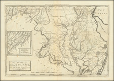
True first state of the Samuel Lewis map of Maryland, from the American Edition of Guthrie's Geography Improved.
The maps from this work were also included in Carey's American Atlas (1795) and Carey's General Atlas (1796). This is the first map of Maryland to appear in a commercial atlas published in America. The map shows counties, towns, roads, rivers, lakes, mountains, islands, and a host of other details. The City of Washington is noted. A large inset shows the western part of the State.
Condition Description
A nice example, with wide margins and a fine dark impression. A bit toned, with occasional soiling. There are also two minor repaired tears, one of which touches the printed image and thother extending about one inch into the map.
![[A chart of New York Island & North River: East River, showing passage through Hell Gate, and the North Shore of Long Island: Flushing Bay, Hampstead Bay, Oyster and Huntington Bay, Cow Harbor]](https://storage.googleapis.com/raremaps/img/small/51531.jpg)

![(Civil War) Stanford's Map of the Seat of War in America. Sheet I. [Mid-Atlantic States]](https://storage.googleapis.com/raremaps/img/small/96007.jpg)