|
||

|

|
|

|
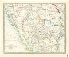
One of the most interesting maps of the United States to appear in a Commercial Atlas, and one of the earliest to extend from Coast to Coast. This edition pre-dates the Gadsden Purchase and includes a large inset of the Gold Region of California. Washington and Oregon extend to the Rocky Mountains. Massive Utah and New Mexico Territories extend from California to the Rockies and beyond. Missouri Territory extends from the Missouri River to the Rocky Mountains and the North Fork of the Platte to Canada, roughly equivalent to what would become Nebraska Territory in 1855. A massive Indian Territory takes on its early Tomahawk configuration. Minnesota Territory includes all of Dakota. This edition of the map is one of the most interesting, during this extraordinary period of geo-political change in the west. Many early roads and explorer's routes are shown, along with Indian Tribes, forts and other details. Exceptional detail in Texas and east of the Sierra Nevada Mountains. Shows Fremont's route, Kearny's Route, the Oregon Trail, Santa Fe Trail, General Arbuckle's route and many others. Other interesting notes on Gold, Silver and Copper mines, Salt Ponds and a host of other early details. Inset map of Washington DC. This map has historically faired poorly in the atlas and has become scarce on the market, much more so than others from this atlas. Minor fold split, else a bright fresh example.
![[Coastal Orange County] Santa Ana Quadrangle](https://storage.googleapis.com/raremaps/img/small/83561.jpg)

![[California, Texas, and Southwest Globe Gore] with [Strait of Anian Globe Gore]](https://storage.googleapis.com/raremaps/img/small/99425.jpg)