This item has been sold, but you can enter your email address to be notified if another example becomes available.


|
||

|

|
|

|
Stock# 11533
Description
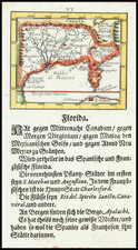
A scarce and extremely desirable map of the Cherokee Nation, shown between the Mississippi, Hogohegee, Savannah and Chattahuche Rivers. Numerous villages and notes are shown, including a note regarding the early explorations by Col. Paively and Mr. Kelly, and additional notes. From the February, 1760 London Magazine, engraved by Thomas Kitchen. The map illustrated an article describing a British expedition against the Cherokee and the importance of obtaining allegiance of the Cherokee to prevent French incursions from the west. One of the most sought after of all maps from th London Magazine. Jolly, Lond-183; Cumming 327; Seller & Van Ee 1387. Nice wash coloring.