
This item has been sold, but you can enter your email address to be notified if another example becomes available.


|
||

|

|
|

|
Stock# 1138p
Description
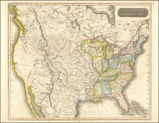
A well engraved and highly detailed map of the United States, one of the earliest appearances of a coast to coast map to appear in a German atlas. Includes marvelous detail in Oregon Territory, Upper California and the Plains and Upper Rocky Mountains. Republic of Texas is shown. Massive early Sioux and Western Territories and a massive Iowa, extending to Canada. The map is particularly detailed in Oregon Territory, showing a 54 40 or fight border. A river connects San Francisco with Salt Lake. A fascinating map, at a time when even American commercial mapmakers were not mapping the US Coast to Coast.
![Gen. Washington [On The Battlefield At Trenton] Engraved by W. Warner from the original picture by Col John Trumbull](https://storage.googleapis.com/raremaps/img/small/103233.jpg)


![[ Massive Misplace Idaho Territory ] The United States of North America.](https://storage.googleapis.com/raremaps/img/small/99361.jpg)