The item illustrated and described below is sold, but we
have another example in stock. To view the example which
is currently being offered for sale, click the
"View Details" button below.
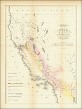
1857 U.S. Pacific RR Survey
$ 750.00

Stock# 1136
Description
Important early geological map of California, prepared to accompany Blake's report on where to locate the transcontinental railroad. Color coded by geological regions, with excellent early detail along the Sierras and in Southern California. A marvelous early map of California.
![[Fruit Crate Label Advertising Map] Star of California Brand](https://storage.googleapis.com/raremaps/img/small/41396.jpg)
![[ Orange County ] Geological Sketch Map S.E. Portion of Orange Co. California State Mining Bureau . . .](https://storage.googleapis.com/raremaps/img/small/76946.jpg)
![[Report and] Map of an Exploring Expedition to The Rocky Mountains in the Years 1842 and to Oregon & North California in the Years 1843-44 By Brevet Capt. J. C. Fremont of the Corps of Topographical Engineers . . .](https://storage.googleapis.com/raremaps/img/small/88488.jpg)