This item has been sold, but you can enter your email address to be notified if another example becomes available.


|
||

|

|
|

|
Stock# 11324
Description
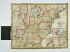
Interesting map of the United States, extending well west of the Rocky Mountains, and showing early state and territorial borders. Arkansas is in its double wide configuration and Missouri appears, but no sign of Iowa and Wisconsin, and Michigan is still shown as a Territory. Massive Huron, District, Sioux District, Osage District, Mandan District and Ozark District. Oregon Territory appears. Texas is named spearately from Mexico, although there is no formal border to the South. A number of early Western Forts appear and nice treatment of the rivers west of the Mississippi, then known.