


|
||

|

|
|

|
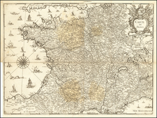
Striking example of Tavernier's rare map of the Postal Routes of France, the first printed postal map of France and one of the earliest European postal maps. The map appeared in Tavernier's Theatre Geographique. A nice old color example, recently refreshed. Embelished with 3 cartouches, coat of arms, sailing ships, etc.
Melchior Tavernier was a member of a large family involved in the publishing trade in Paris in the early years of the seventeenth century. Early in his career, he apparently collaborated with Henricus Hondius, as at least one of his early maps references Tavernier as the seller of a map engraved in Amsterdam, by Hondius. He is probably best known for his publication of a map of the Post Roads of France, which was copied many times until the end of the century. He also issued an atlas under the same title as J. le Clerc's Theatre Geographique, using many of Le Clerc's maps, but incorporating others from different sources. He published composite atlases and also published works for other cartographers, including N. Sanson, N. Tassin, and P. Bertius. He is not to be confused with his nephew of the same name (1594-1665), who also engraved maps for Nicolas Sanson.
![[ Holy Roman Empire, Poland, Baltic, etc. ] Germania VI Nova Tabula (First state!)](https://storage.googleapis.com/raremaps/img/small/94645.jpg)
![[ France ] Galliae Regionis Nova Descriptio](https://storage.googleapis.com/raremaps/img/small/81285.jpg)
![[France] Europae Tabula III](https://storage.googleapis.com/raremaps/img/small/60010.jpg)