


|
||

|

|
|

|
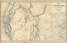
Gorgeous example of this large format separately issued map of Arizona Territory, printed by Julius Bien & Co. in New York. The map key helps identify the office of the Surveyor General, US Land Offices, County Seats, completed railroads, railroad land grant limits, military reservations, private grants confirmed, private grants unconfirmed, Indian Reservations, counties and townships. Many of the treaty/settlement dates are shown, along with private ranches and many other fine details. Dissected and laid on linen, as issued, with a University of California Library stamp o the verso and a note that the map was a gift of the London Assurance Co. Perhaps the single best obtainable map of Arizona during the period.
The General Land Office (GLO) refers to the independent agency in the United States that was in charge of public domain lands. Created in 1812, it assumed the responsibilities for public domain lands from the United States Department of the Treasury. The Treasury had overseen the survey of the Northwest Territory, but as more area was added to the United States, a new agency was necessary to survey the new lands.
Eventually, the GLO would be responsible for the surveying, platting, and sale of the majority of the land west of the Mississippi, with the exception of Texas. When the Secretary of the Interior was created in 1849, the GLO was placed under its authority. Until the creation of the Forest Service in 1905, the GLO also managed forest lands that had been removed from public domain. In additional to managing the fees and sales of land, the GLO produced maps and plans of the areas and plots they surveyed. In 1946, the GLO merged with the United States Grazing Service to become the Bureau of Land Management.


![La Parte Occidentale Dell'Antico, E Nuovo Messico Con Florida E La Bassa Luigiana…. 1798 [California & The Southwest!]](https://storage.googleapis.com/raremaps/img/small/95816.jpg)