This item has been sold, but you can enter your email address to be notified if another example becomes available.


|
||

|

|
|

|
Stock# 11135
Description
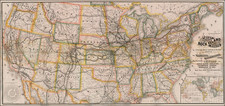
Detailed map of the United States, extending from the Louisana to the Atlantic. Includes a massive Iowa Territory, extending to Canada, and oversized Wisconsin. Colored by states. Shows towns, rivers, roads, railroads, mountains, lakes, etc. Very primitive treatment of Iowan and Minnesota, which are dominated by Sioux Country. Adam & Charles Black were among the leading publishers of atlases and travel books in the 19th Century England.
![[Pocket Atlas of Denison's Annual and Seasonal Climatic Maps of the United States] Descriptive Circular of The Annual and Seasonal Climatic Maps of the United States . . . .](https://storage.googleapis.com/raremaps/img/small/88162.jpg)

![(Coast of Florida, Georgia and the Carolinas] [To The Members Of The Nautical Institution And Ship-Masters' Society Of The City Of New York, This Chart, Extending From Lat. 40°15 N., Long. 72°15 W., to Lat. 22°35 N., Long. 80°25 W., Is Respectfully Dedicated / By Their Obedient Servant Edmund M. Blunt]](https://storage.googleapis.com/raremaps/img/small/77294.jpg)