|
||

|

|
|

|
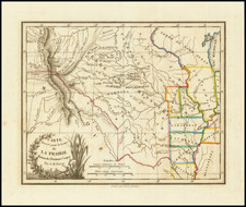
Highly detailed map of the region between Salt Lake and Bridger's Pass. Extends north to Fremont's Peak and west to include the Lewis Fork of the Columbia. Bonneville's Old Fort, South Pass and Independence Rock are also shown in the North. In the southeast, the map extends to the Little Snake River, the Yampa or Bear River and White River,, showing Stansbury's Route in 1850. In the south the map extends south of Lake Utah to Nephie City and a place marked simply Settlement. The map is centered on Ft. Bridger. Includes excellent detail in the Salt Lake area, nameing many rivers, and the various settlemnts along the western slope of the Wasatch Mountains.There are also a number of early roads, some named and others not, including Kinney's Cut Off a nd the path of the Timpanagos River, by then reduced to myth. Ft Utah, Lehi, Lake City, Palmyra, Payson City, Pleasant Grove, Holmes Height, Philips, Ogden City, and Ferry are all named. A marvelous regional map immediately prior to the Civil War. Wheat 958.