


|
||

|

|
|

|
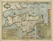
Rare old color example of this early edition of Mercator's map of the British Isles, from the 1584 edition of his Tabulae Geographicae, the first atlas published by Mercator. Shirley notes that the Tabulae Geographicae was the earliest part of Merctor's life long plan to describe the whole of the ancient and modern world both geographically and historically. The ancient map of the British Isles has been finely drawn and engraved by Mercator himself. The townsw and cities are named and shown with symbols which by then had become generally accepted. On the verso is an explanation of how the map has been converted from Ptolemy's projection to that used by Mercator. First issued in 1578, this later edition is identifiable by the page number B on the verso. The map very rarely appears on the market, especially in such fine old color. Shirley 123.

![[ Genealogy of the English Monarchy ] Reges Angliae Inclijto ac Potentiss](https://storage.googleapis.com/raremaps/img/small/99752.jpg)