Nearly flawless example of Fremont's seminal map of the West.
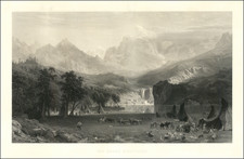
Wheat dedicates 13 pages and 2 illustrations to this map, which more than any other map before or after its publication embodied the changing American West.
Fremont went to California in 1845, making new and important explorations enroute, especially in the Great Basin. He proceeded north to Klamath Lake and was then summoned back to Monterey to participate in the Conquest of California. He later was appointed the first Governor of California and later arrested and found guilty of mutiny. It is beyond the space available here to describe all of the significant cartographic advances set forth in this map.
As noted by Wheat, though the map is not without defects, it is a wonderfully graphic report on where the expedition of 1845-46 went and what it saw. Great credit must be given to Edward M. Kern [for the topographical work] . . . . As a contribution to cartographical knowledge, the case for the map's importance was well put by Fremont himself . . . In extent, it embraces the whole western side of this continent beween the eastern base of the Rocky Mountains and the Pacific Ocean, and between the straits of Fuca and the Gulf of California . . . It is, without question, the most influential map of the region during the 19th Century and a centerpiece to any western map collection.
![[ Sonoma County ] Map of Sonoma County California Showing New Boundary Lines of County and Townships, Private Claims and Ranches, Government Townships and Section Lines, Rail Roads and Public Roads Water Works Cities Towns School Districts, etc. Carefully Compiled From The Latest Authorities By R.A. Thompson, County Clerk . . . 1884](https://storage.googleapis.com/raremaps/img/small/99877.jpg)
![[Report and] Map of an Exploring Expedition to The Rocky Mountains in the Years 1842 and to Oregon & North California in the Years 1843-44 By Brevet Capt. J. C. Fremont of the Corps of Topographical Engineers . . .](https://storage.googleapis.com/raremaps/img/small/88488.jpg)
![[ Before The Salton Sea ] [ Official Map of San Diego County compiled from latest official maps of U.S. surveys, railroad and irrigation surveys, county records, and other reliable sources . . . Northeast Sheet ]](https://storage.googleapis.com/raremaps/img/small/101378.jpg)