|
||

|

|
|

|
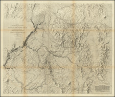
Rare 1850 edition of Mitchell's map of the West, one of two post 1849 editions which predates the formation of Washington Territory. Oregon extends to Missouri Territory and the Rocky Mountains. No counties are shown east of the Cascades. Only Los Angeles and San Diego Counties appear south of Mariposa and Santa Barbara Counties (and the California Counties are note yet colored. The Bartlett and Graham Line's which appear in the 2nd edition of the map, are not yet shown. Kearney's Route is shown, as is the Spanish Trail from Santa Fe to Los Angeles. The Oregon Route is also shown, as is Fremont's route and Cook's Wagon Route. Many early forts and Indian Tribes appear. The boundary of 1819 with Spain is also shown, pre-dating California's annexation into the US. Massive Tule Lake and no sign of Lake Tahoe. The two 1850 editions of the map are easily distinguished. This, the first edition of the map, has no counties in Oregon, Utah and New Mexico, whereas the second edition of the 1850 map has counties along the coast of Oregon and throughout Utah Territory and New Mexico. This map is technically the last of the 1846-1849 series, which extends only to the Rocky Mountains. In the edition of 1859, the map is completely re-engraved, with the new plate extending further east of the Rocky Mountains, to incorporate most of Colorado (then still Indian Territory). One minor tear, just touching the image, but stil a nice example of this rare edition of the map.
![[ Lake County Rancho ] Map of the Guenoc County Rancho Finally Confirmed To A.A. Ritchie & P.S. Forbes, Surveyed under the Direction of the U.S. Surveyor General By Wm. Denton Deputy Surveyor. June 1857.](https://storage.googleapis.com/raremaps/img/small/102630.jpg)