|
||

|

|
|

|
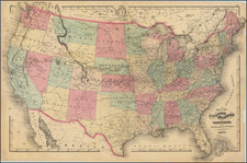
John Melish's map of the United States is the single most important and influential map of America published in the 19th Century and is rivaled only by John Mitchell's map of North America in 1755 as the single most influential map in American History. Described by Thomas Jefferson as a luminous view of the comparative possessions of different powers in our America, Melish's map, first issued in 1816, was the first indigenous attempt to map the United States from coast to coast and synthesized the works of Lewis & Clark, Humboldt, Pike, Arrowsmith and others for the first time in a single large format coast-to-coast mapping of the United States. Much as Mitchell's map influenced boundary disputes and treaties in North America for nearly a century after its publication, the Melish map similarly became the essential source map for the 19th Century. It has been described by several commentators as the visual embodiement of Manifest Destiny to an American public searching for a graphic depiction of America's territorial acquisitions from coast-to-coast in the early 19th Century. Following the Louisiana Purchase, Americans turned there attention westward to the great expanse from the Mississippi River to the Pacific Ocean. While the explorations of Lewis & Clark and Zebullon Pike provided early regional snapshots of previously unknown regions in the West, it was left to Melish to tie together these works, along with Arrowsmith's map of Mexico and other available sources, into the first systematic and comprehensive map of the US. Prior to his map of the US, Melish had produced a number of other highly acclaimed regional maps and his rare Military & Topographical Atlas of the United States. However, this map of the US would become his masterwork, ultimately reissued in 25 known states of the map between 1816 and 1823. The most notable advance in the later states of the map is the addition of an extra plate at the bottom of the map, which provided coverage of Cuba, Jamaica, the Virgin Islands and the remainder of the Gulf Coast and the Yucatan to the map. The map, in its various editions, faithfully recorded the changing geography of the US, as various boundary disputes, treaties and explorations extended both the geographical territory of the US and a young nation's knowledge of its own territory. The US-Mexico boundary established by the Adams-Onis Treaty of 1819 was laid out on a copy the 1819 edition of the map. Melish reportedly released only 100 copies of each edition. Because of the map's size and its use as a official source, relatively few copies have survived. This is specially true for the the later editions, this being the first example of the 1823 (and last) edition of the map to appear on the market in a number of years.These later editions are substantially revised, with extensive corrections along the entire Northern Border of the US and in the treatment of Lake Michigan. Beginning in 1820 Arkansas Territory appears and the Northern border of Tennesee is corrected per Act of Congress ratified May 12, 1820. Beginning with the 1822 edition, the US-Canada border is correctly shown to lie along the 49th parallel from the Lake of the Woods to the Rocky Mountains, correcting the erroneous treatment of the line as extending to the Gulf of Georgia (Puget Sound) which had been shown in prior editions, contrary to the Treaty of 1818. Chicago is now on Lake Michigan w/o the need of a panhandle in Illinois. Missouri appears as a state (admitted August 1821). In the 1822 edition, a number of new Western Roads have been included, including the Kansas Road, running into the Road to the Pawnees, which in turn joins the Great Spanish Trail. Lake Timpanagos appears for the first time in 1822, as does New Albion and New California. The present example is segmented and mounted on linen. All of the original silk edges are present, including the extensions for hanging the map. This example also includes unsually wide margins for the map, which is generally trimmed close to the neatline. There are none of the usual splits or damage to the linen, which includes an ornate large coat of arms printed on the the verso. A bit toned, but with strong attractive color. A bit of soiling along the lower neatline and just entering into the map. In all, a very nice example of this seminal American map. Ristow, American Maps & Mapmakers, p446; Ristow, A la Carte pp 162-182; Schwartz & Ehrenberg pp 238-239, pl. 233; Wheat II, no 322, pp. 62-64.
John Melish (1771-1822) was the most prominent American mapmaker of his generation, even though his cartographic career lasted only a decade. Melish was born in Scotland; he moved to the West Indies in 1798 and then to the United States in 1806. By 1811, he had settled in Philadelphia and published Travels through the United States of America, in the years 1806 & 1807, and 1809, 1810, & 1811, which was richly illustrated with maps.
Melish created several regional maps of the highest quality, as well as the Military & Topographical Atlas of the United States (Philadelphia, 1813, expanded 1815). The latter work is widely considered to be the finest cartographic publication to come out of the War of 1812.
By far his best-known work is his monumental map of the United States of 1816, Map of the United States with the contiguous British and Spanish Possessions. He began working on the map in 1815 and sent it to Thomas Jefferson for comment in 1816. Jefferson enthusiastically reviewed the map and returned it with his edits. Jefferson later hung an example of the map in the Entrance Hall of Monticello and sent it to associates in Europe.
Melish’s finished product was the first map of the United States to extend to the Pacific Ocean. After its publication in 1816, Melish ensured the map was as up-to-date as possible; it was reissued in 25 known states published between 1816 and 1823. The map captured the then rapidly changing geography of the United States, as well as various boundary disputes, treaties, and expansion.
![For Governor, Maj. Gen. John W. Geary [Former Mayor of San Francisco / Governor of Kansas Territory and Governor of Pennsylvania]](https://storage.googleapis.com/raremaps/img/small/93592.jpg)
![Colton's United States Shewing Military Stations, Forts &c. . . . 1861 [Shows Slave, Free and Border States -- Printed For British Market]](https://storage.googleapis.com/raremaps/img/small/103234.jpg)
![[ Missouri named State of Jefferson ] Etats-Unis par A.M. Perrot](https://storage.googleapis.com/raremaps/img/small/99019.jpg)