This item has been sold, but you can enter your email address to be notified if another example becomes available.


|
||

|

|
|

|
Stock# 10446
Description
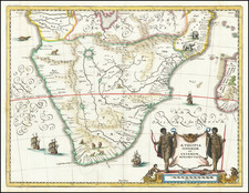
Marvelous and highly detaile degional map of the southern half of the Continent and Madegascar. Extends north to include St. Thomas Island and Corsico Bay, all of the Congo River, Unjaro, Lake Baringo and part of Somalia. Details include towns, Tribes, rivers, mountains, deserts, territories, permanent & seasonal rivers, salt, freshwater and seasonal lakes and many other details. 15 explorers routes located, including Pobeiros, Monteiro, Livingston, Krapf, Ladislaus Magyur, Silva Porto, Montaha, Hahn & Rath, Speke, Von d. Decken, Raines, Baker, Mauch, Du Chailtu and Hahn, covering the perior from 1806 to March of 1868. Wonderful map, with more detail than any other atlas map of the era.
![Colton's Africa [Southern Sheet]](https://storage.googleapis.com/raremaps/img/small/98349.jpg)
![[ West Africa ] A Chart of Guinea Describing the Seacoast from Cape de Verde to Cape Bona Esperanca](https://storage.googleapis.com/raremaps/img/small/99962.jpg)