|
||

|

|
|

|
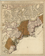
Highly detailed map of the area around Charleston, South Carolina (founded 1669), based upon the surveys and manuscript maps of Maurice Mathews and an extremely rare map of South Carolina by Thornton and Morden, published ca. 1695 and is widely regarded as the first obtainable map of the region around Charleston to appear in a Commercial Atlas. The map extends from the Edisto River in the South to the Sewee and Santee Rivers in the North, cetnered on Charles Town and the Cooper River. While the title is in French, the map includes the names of dozens of early landowners around Charleston and along the coastline and the major rivers, extending far up the Ashley and Cooper Rivers, Goos Creek, Edisto River and Wando River. At the northernmost point on the Cooper River, the Santee Indian Fort, Faralaunes, and the Colleton's Barony are shown. Sir John Colleton (1608-1666) lost most of his property to the forces of Parliament, but was later knighted by Charles II, upon restoration of the Stuart Monarchy. He was a member of the Council for Foreign Plantations and of the Royal African Company which introduced slavery into British possessions in North America. He was one of the 8 proprietors of the Carolina grant and actively interested in its sucess, although he died relatively shortly after its creation in 1665. The map also notes a number of Indian Settlements and shows the early roads in the region. A marvelous example, in original color. Cumming 121. Second state, with the plate number added to the map. An essential map for South Carolina Collectors.
Johannes Covens (1697-1774) was a Dutch geographic publisher based in Amsterdam. He is best known for his collaboration with fellow publisher Cornelis Mortier (1699-1783). Pierre Mortier the Elder (1661-1711) had obtained a privilege in 1690 to distribute the works of French geographers in the Netherlands. After his widow continued the business for several years, Cornelis took over in 1719.
In 1721, Mortier forged a partnership with Covens, who had recently married Cornelis’ sister. They published under the joint name of Covens & Mortier. In 1774, upon the death of his father, Johannes Covens II (1722-1794) took over his father’s share. In 1778, the company changed its name to J. Covens & Zoon, or J. Covens & son.
Covens II’s son, Cornelis (1764-1825), later inherited the business and brought Petrus Mortier IV back into the fold. Petrus was the great-grandson of Petrus Mortier I. From 1794, the business was called Mortier, Covens & Zoon, or Mortier, Covens, & Son.
The business specialized in publishing French geographers including Deslisle, Jaillot, and Sanson. They also published atlases, for example a 1725 reissue of Frederik de Wit’s Atlas Major and an atlas, with additions, from the works of Guillaume Delisle. There were also Covens & Mortier pocket atlases and town atlases. The company profited from acquiring plates from other geographers as well. For example, the purchased Pieter van der Aa’s plates in 1730. Finally, they also compiled a few maps in house. At their height, they had the largest collection of geographic prints ever assembled in Amsterdam.
Cornelis Mortier (1699-1783) was a Dutch publisher who specialized in geography. Cornelis’ father, Pierre Mortier the Elder (1661-1711), had obtained a privilege in 1690 to distribute the works of French geographers in the Netherlands. After his widow continued the business for several years, Cornelis took over in 1719.
In 1721, Mortier forged a partnership with Johannes Covens, who had recently married Cornelis’ sister. They published under the joint name of Covens & Mortier. Their firm was one of the largest and most successful in Dutch history and continued in business until the late-nineteenth century.
In 1774, upon the death of his father, Johannes Covens II (1722-1794) took over his father’s share. In 1778, the company changed its name to J. Covens & Zoon, or J. Covens & Son. Covens II’s son, Cornelis (1764-1825), later inherited the business and brought Petrus Mortier IV back into the fold. Petrus was the great-grandson of Petrus Mortier I. From 1794, the business was called Mortier, Covens & Zoon, or Mortier, Covens, & Son.
The business specialized in publishing French geographers including Deslisle, Jaillot, and Sanson. They also published atlases, for example a 1725 reissue of Frederik de Wit’s Atlas Major and an atlas, with additions, from the works of Guillaume Delisle. There were also Covens & Mortier pocket atlases and town atlases. The company profited from acquiring plates from other geographers as well. For example, the purchased Pieter van der Aa’s plates in 1730. Finally, they also compiled a few maps in house. At their height, they had the largest collection of geographic prints ever assembled in Amsterdam.