|
||

|

|
|

|
Stock# 10350
Description
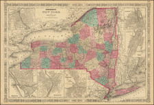
Scarce separately issued map of the state of New York, issued by Charles Magnus. Mangus published birdseye views, letter sheets and separately issued maps during the Civil War. This map was apparently intended to be issued in pocket map format, but was never folded. The map is colored by counties and shows railroads, common roads, canals, towns, rivers, and a host of other information. Insets of Long Island and a large view of Niagara Falls. This example was part of a remainder collection which was never folded. Minor bit of repair near the centerfold. Backed with japan paper to support Magnus' notoriously thin paper. A nice example of this rare pre-Civil War decorative map.

![(American Revolution) [Manuscript Map of New York City and Northern New Jersey]](https://storage.googleapis.com/raremaps/img/small/69609.jpg)
![Map of the State of New York with Part of Upper Canada [Large inset plan of New York]](https://storage.googleapis.com/raremaps/img/small/91848.jpg)