


|
||

|

|
|

|
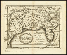
Important early map showing much of the US south of the Great Lakes and extending east to include much of Texas. The Mississippi is shown far west of its true location, with an unusual southeasterly course. Extensive Indian tribes named. The map is based upon the 1657 map of Nicholas Sanson, as well as earlier nomenclature in Chaves map of Florida. Du Val's primariy deviations are in the Texas and Mississippi Drainage regions, where he names the Rio del Spiritu Santu, Mar Pequeno, Rio de Canaveral and other new details. The French claims to Florida are evident. A seminal map for collectors of Texas, the South, Florida and the Mid-Continent regions of the US. Cumming 57, Burden 352 (State 2), Pasterneau pp135-7 & 162-5.
Pierre Duval (1618-1683) was a French geographer, cartographer, and publisher who worked in Abbeville and Paris during the seventeenth century. He was born in the former city, in northeast France, before moving to Paris. Duval was the nephew of the famous cartographer Nicolas Sanson, from whom he learned the mapmaker's art and skills. Both men worked at the royal court, having followed the royal request for artists to relocate to Paris. In addition to numerous maps and atlases, Du Val's opus also includes geography texts. He held the title of geographe ordinaire du roi from 1650 and died in 1683, when his wife and daughters took over his business.
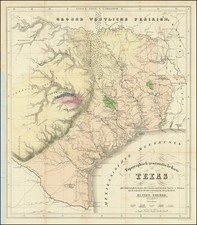
![[ Indian Territory / North Texas / Arkansas ] General Topographical Map. Sheet XXIV. Plate CLIX](https://storage.googleapis.com/raremaps/img/small/95113.jpg)
![[ Texas Pictorial Map Artwork ]](https://storage.googleapis.com/raremaps/img/small/65261.jpg)
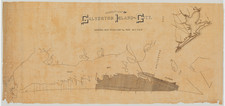
![[Manuscript Map and Grant Translation for Adolphe Sterne's Lands in Tyler County, Texas] Translation of Title to One League of Land to Adolfo Sterne [Tyler County, Texas land grant]](https://storage.googleapis.com/raremaps/img/small/85549.jpg)