|
||

|

|
|

|
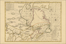
The only known example of one of the earliest seperately published sea charts of New Netherlands.
The map extends from the English Colony of Virginia to Cape Cod. The engraving style is similar to the work of Jacobsz and his charts of circa 1650.
New Sweden is not located, which may suggest that the map was engraved shortly after the overthrow of the colony in 1655.
The map is known to have survived in a single copy of de Vries' Korte Historiael ende Journaels Aenteyckeninge van Verscheyden Voyagien, pubished in Amsterdam in 1655, whic hwas acquired by us in 2004 and sold to a private collector. A copy of the book, with maps, is also known to have been in the Library of Prince Roland Bonaparte in teh early 1900s. It is certainly possible that the example we acquired in 2004 is the same example of the map.
Burden has opined that this map is the source of Colom's sea chart, rather than vice versa.
![(Early Philadelphia Architectural Drawings) Plan of the ceiling of St. Andrews Church [with two additional drawings on another sheet]](https://storage.googleapis.com/raremaps/img/small/90443.jpg)
![New Jersey [with insets] Vicinity of Camden [and] Vicinity of Jersey City](https://storage.googleapis.com/raremaps/img/small/89264.jpg)
![[Portland & Cape Elizabeth to Moskito Island -- Centered on Kennebec River]](https://storage.googleapis.com/raremaps/img/small/50079.jpg)