|
||

|

|
|

|
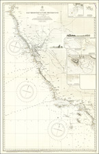
Facsinating and highly details map of the region from Altruas, California in the Northwest, to Fredonyer's Peak in the Southwest, Deep Hole (just north of Gerlach) in the Southeast and the Sheldon National Wilderness Rerserve in the Northwest. Includes a number of Old Emigrant Roads in the region. McDonald Peak, South Fork, Obervation Peak, Shinn's Peak, Ganity Peak, Hat Peak, Eagle Peak, Warren Peak, and Mahagony Peak are among the mountains referenced. A number ofearly roads are shown, alont with several very small towns, stage coach stations, springs, creeks, salt works, cabins and many other minute details in the region. The most detailed map of the region to date. Produced by order of the Secretary of War. Scale 1 inth to 4 miles. The Wheeler Survey was the most detailed systematic survey of the West and provided the first truly detailed and accurate maps of many fascinating and remote regions of the West.