|
||

|

|
|

|
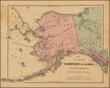
Remarkable double page map of Alaska and the Northwest, along with the contiguous parts of the Pacific and Russia. The most remarkable feature of this rarely seen gem is the isothermal lines by Lorin Blodgett. This is the first example of this map we have ever seen. We believe the map was only issued in one or two editions of the Atlas. An excellent addition to Alaskana collections.
G. W. & C. B. Colton was a prominent family firm of mapmakers who were leaders in the American map trade in the nineteenth century. The business was founded by Joseph Hutchins Colton (1800-1893) who bought copyrights to existing maps and oversaw their production. By the 1850s, their output had expanded to include original maps, guidebooks, atlases, and railroad maps. Joseph was succeeded by his sons, George Woolworth (1827-1901) and Charles B. Colton (1831-1916). The firm was renamed G. W. & C. B. Colton as a result. George is thought responsible for their best-known work, the General Atlas, originally published under that title in 1857. In 1898, the brothers merged their business and the firm became Colton, Ohman, & Co., which operated until 1901, when August R. Ohman took on the business alone and dropped the Colton name.